Introduction
In early March 2020, the COVID-19 pandemic caused many businesses and schools to modify operations to help stop the spread of the virus. This was soon after followed by state and local officials implementing stay-at-home orders. While a phased reopening is beginning in many jurisdictions, a return to “typical” traffic patterns is unlikely in the foreseeable future given the best available information at this time from public health officials modeling the virus’s impact. Telecommuting and staggered schedules are expected to remain a significant way people will live, work, and learn. We do not know when typical traffic conditions will return, and we also do not know if typical conditions will be the same as pre-COVID-19.
A vehicular capacity analysis, included as part of our multimodal transportation impact studies, relies heavily on current intersection turning movement counts (TMCs). For these reasons, in collaboration with StreetLight Data, we have developed a methodology to assemble baseline traffic count data representative of existing typical conditions. The methodology presented in this white paper uses StreetLight to determine traffic patterns during pre-COVID conditions at intersections without previously collected TMCs. Determining the pre-COVID traffic patterns enables us to extrapolate nearby historical count data to the intersections that are missing count data, in lieu of field collected TMCs. The usefulness of StreetLight in analyzing regional origin-destination traffic patterns is well-documented. Using the platform to determine traffic patterns at the intersection-level to estimate TMCs is a natural progression of the platform, making it a preferred tool for this approach. This methodology may be used until it is determined that prevailing traffic commuting patterns have settled back to typical, consistent weekday peak period patterns post-COVID-19.
Data Sources
StreetLight is a tool that uses “Big Data” comprised of two types of locational data: Location-Based Services (LBS) data and navigation-GPS data. The data is indexed and processed using an algorithm to transform the data into travel patterns on roadways. LBS data is derived from anonymous user location data from mobile applications. While this data typically has very large sample sizes, it has low spatial precision (5 to 25 meters) and ping rates. Navigation-GPS data is derived from commercial fleet navigation systems, navigation-GPS devices in personal vehicles, and turn-by-turn navigation mobile applications. While this data has very high spatial precision (5 meters) and ping rates, the sample sizes are typically small.
StreetLight data has been collected over several years and allows users to select which data to include in an analysis. The data can be filtered by data period, days of the week, and time of day. The sample size and penetration rates of the available StreetLight data vary by location and specific analysis parameters.
Methodology Framework
In collaboration with StreetLight, Gorove Slade has developed a methodology to assemble baseline traffic count data where field-collected turning movement counts are not available. The methodology assumes that historical field-collected count data exists at a portion of the study area intersections or nearby intersections. StreetLight data will be used to extrapolate historical count data to intersections that are without data, according to the following methodology:
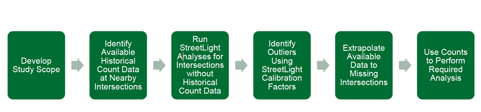
Step 1 – Develop Study Scope
- Work in consultation with the reviewing agency(s) to identify study area intersections and study time periods
Step 2 – Identify Available Historical Count Data at Nearby Intersections
- Counts should have been taken prior to March 1, 2020
- Counts taken within the last two years are preferable, but if not, older available counts will be considered
Step 3 – Run StreetLight Analyses for Intersections without Historical Count Data
- Identify missing study intersections
- Identify ADT/AADT data for analysis calibration
- Run a StreetLight InSight O-D analysis at intersections without historical count data for the same time period as the nearby available historical count data
- Use months of StreetLight data that best suit the desired seasonality of intersection counts
- Use days of the week that best meet the analysis needs
- Use StreetLight Index as the output
Step 4 – Identify Outliers Using StreetLight Calibration Factors
- Calculate the calibration factors for each ADT/AADT location to identify any outliers
- Adjust the StreetLight Index, as needed, based on knowledge of the study area and engineering judgement
Step 5 – Use StreetLight Index to Extrapolate Available Data to Missing Intersections
- Calculate turning movement ratios from StreetLight Index output
- Grow historic counts to current year conditions using adopted travel models
- Extrapolate historical count data to intersections without count data, based on calculated turning movement ratios, to estimate count data
Step 6 – Use Counts to Perform Required Analysis
- Perform analysis and identify resulting mitigations
Validation
Based on multiple validation metrics, including GEH statistics and intersection performance comparisons using Synchro, the methodology outlined in this paper is a suitable solution for obtaining baseline traffic count data to continue vehicular capacity analyses. While the possibility of discrepancies between extrapolated data and field-collected data does exist, knowledge of the pre-COVID-19 traffic conditions within the study area combined with proper engineering judgement allows necessary adjustments made to the data to minimize error.
Mitigations
As part of the multimodal transportation impact study process, mitigations are often recommended based on the results of the vehicular capacity analysis. Given the uncertainty of post-COVID-19 conditions, efforts should be made to identify any mitigations that could potentially not be warranted, should future traffic conditions be significantly different than pre-COVID-19 conditions. A post-COVID-19 monitoring plan could be established if it is desirable for mitigations to be revisited once post-COVID-19 conditions are realized.
It is worth noting that this methodology only addresses the conditions of vehicular traffic. Since early March, both auto and non-auto travel modes have seen drastic shifts in volumes. Travel patterns are expected to remain below historic volumes and without any predictable consistency for all travel modes until the COVID-19 pandemic is no longer a factor. While volumes are anticipated to return to near pre-COVID-19 levels, it is important to closely monitor all travel modes to assess any impacts.
Conclusion
We do not know when typical traffic conditions will return, and we also do not know if typical conditions will be the same as pre-COVID-19. The seemingly temporary changes to the way people live, work, and learn may have lasting impacts on transportation patterns. However, it is reasonable to assume pre-COVID-19 conditions as a baseline for assessing impacts until our industry and reviewing agencies decide otherwise. The combination of historical field-collected data and Big Data allows us to leverage both long-proven transportation engineering techniques and emerging technologies, creating a powerful methodology for continuing transportation projects during atypical conditions.